
Quick Link: Doppler weather Radar, Miami
Weather links including some great ones for Tropical Storms and Hurricanes
Purdue WXP GOES-8 Satellite
Images ![]()
![]()
![]()
This site contains a nice menu of GEOS-8 satellite images and satellite loops. The pic below is the current Water Vapor Image. Click for a closer view or the satellite images link above for the complete selection.

Great
up and comer from University of Hawaii... Great color
GEOS8 satellite images...![]()
![]()
![]()
![]()

Florida-Bahamas-Cuba view from GEOS-8
Miami Weather Forecast (Univ of Miami)
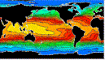 NOAA El
Nino Information
NOAA El
Nino Information |
National Weather Service Home Page |
| Marine Charts on the Net | |
| UofM | Global Wave Height Map |
| FSU
CAUTION: Do not rely on FSU for information when tropical storms approach the mainland. They frequently shut down access to non .edu and .gov sites Interactive Marine Buoy System Interactive Marine Weather / Florida |
|
| Weather Link Page | |
| Hurricane Forecasts from Colorado State (Dr. Gray) | University
of Hawaii Weather Server
|
| Weather Cameras around the USA | Miami Nexrad |
| WeatherNet! | Miami Regional Summary |
Tropics:
Sea Surface Temperature DisplaysDifficult to find, these are among the only free sources of imagery of sea surface temperature These same charts are analyzed and 'upgraded' and sold to consumers.
|
|||||
Rutgers
|
Johns Hopkins |
||||
rec.outdoors.fishing.saltwater
Current GOES East Water Vapor Satellite Picture
![]()
Barracuda Bonito Bonefish Dolphin Permit Sailfish Salmon Snook Tarpon Fishing
Trees - Boating - Fishing -Boca Raton Fishing Club - Sailing - Weather - News - Main page

